Cotswold District Council is, on its own account, in a housing emergency. Its figures put it at 1.8 years of housing land against a five-year requirement, after the government's December 2024 standard method raised the district's annual target from 493 homes to 1,036. The Council's own report spells out the consequence: its main housing policies are now "out-of-date," and applications must be decided under the presumption in favour of development and the tilted balance. In plain terms, the shortage is the reason schemes get waved through.
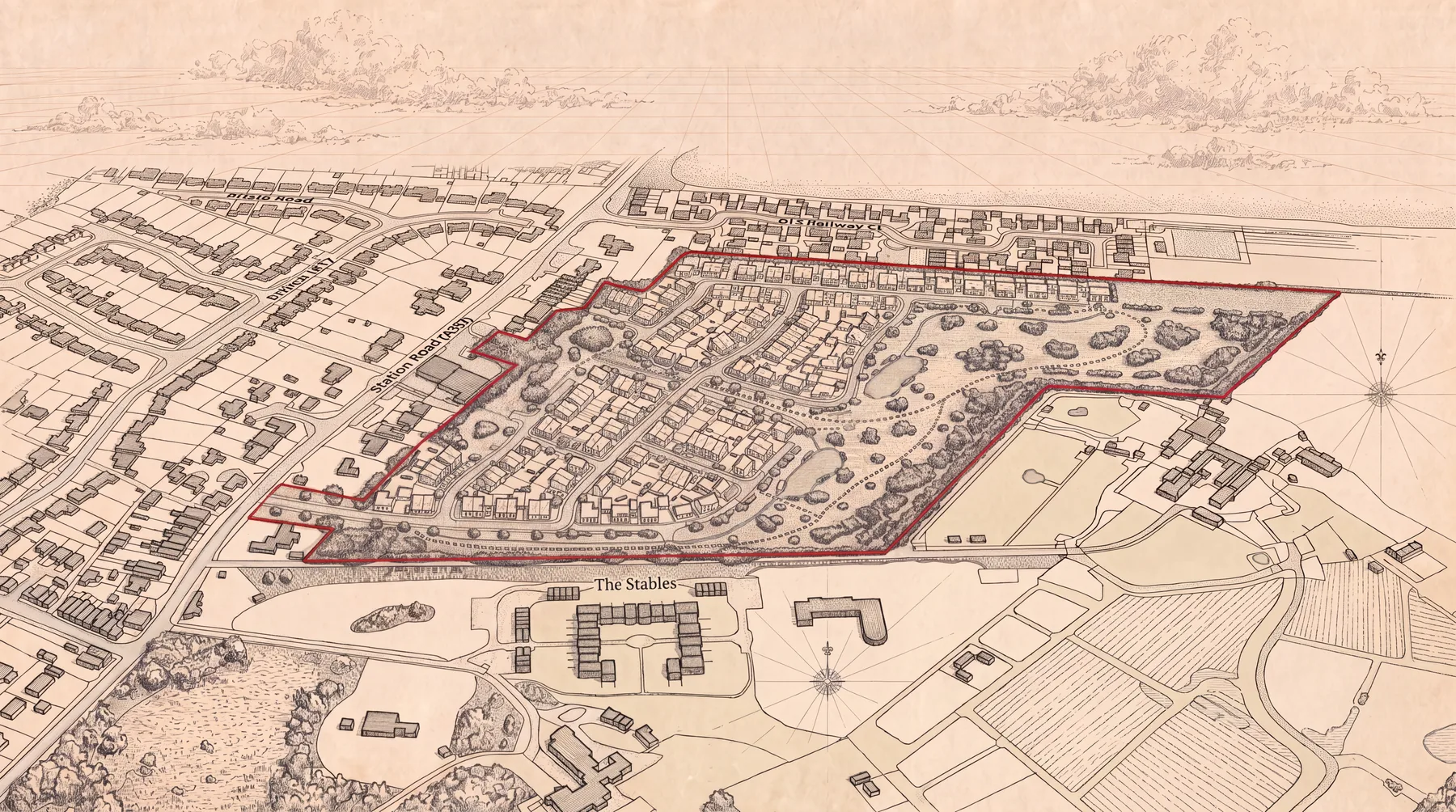
On a field south of Ferrers Park, on the edge of Lechlade, the developer Ashflame Properties wants to build up to 150 homes. The emergency is the argument for letting it. And there is one difficulty with that argument, which is that the same Council has already counted the growth. Its own preferred Local Plan strategy, set out in the Development Strategy Options report of November 2025, banks substantial new housing on Lechlade as part of the supply it is planning to deliver by 2043, and this site is part of that growth. The application to actually build the homes, reference 25/04047/OUT, has not been determined. The Council is short of the very supply it has already counted.
That is the spine of this story, and everything else hangs off it. A council cannot coherently be so desperate for housing supply that the tilted balance must carry a scheme through, while at the same time treating that same growth as supply it is relying on for the next eighteen years. One of those positions has to give.
The SHELAA capacity of 86 dwellings, and an application for 150.
Start with the figure itself, because it sits oddly against the Council's own evidence. When the Council assessed this land in its Strategic Housing and Economic Land Availability Assessment, the site, listed there as L33, was given an indicative capacity of 86 dwellings. That figure carries a caveat in the Council's own words, and the caveat matters: the 86 comes from applying a density assumption to half the site area, so it was never a finding that the field could hold no more than 86. The same document also records the site being put forward at 100 homes in its April 2021 assessment and at 190 homes in its summary table. Ashflame's application is for 150.
So the objection is not that 150 is a bigger number than 86. It is that the reasoning between the two has never been published. The Council's preferred strategy counts growth on this scale at Lechlade without setting out what it now judges the site can actually take, or why, and the body doing that counting is the same body that will decide the application.
The site is 9.87 hectares of agricultural land, with its proposed access from Station Road. The application's address is Land Parcel East of Cotswold Bungalow, Burford Road, Lechlade, and Land south of Ferrers Park is the promoter's and the SHELAA's name for the same land. Of the site, 82 per cent is classed as best and most versatile farmland, the grade national policy says should be kept where possible. It lies around 80 metres from the Cotswold Water Park, a Site of Special Scientific Interest, and immediately next to the Lechlade Conservation Area, with three Grade II listed buildings within 130 metres. None of that is in dispute. It is in the developer's own documents.
Why Lechlade, and the gap in the constraint map.
There is a reason a field like this is in the frame at all, and the Council's strategy says it out loud. Around 80 per cent of Cotswold district lies within the Cotswolds National Landscape, where national policy limits what can be built. So the Council's preferred strategy steers growth towards the settlements that sit outside the designation. Lechlade is one of the few principal settlements marked as outside it. The report records that settlements inside the National Landscape would receive less development than those wholly or partly outside it (paragraph 5.5).
That reasoning does a great deal of work. The constraint map mostly sees one thing, the National Landscape, and Lechlade is not in it. What the map does not register is the SSSI 80 metres away, the conservation area over the boundary, the listed farmhouse, the protected species, the best farmland. A town gets selected not because the land is well suited to housing, but because it lacks the one label that would have shielded it. The growth follows the gap in the designations, not the suitability of the ground.
The case for the homes is not nothing, and it should be put fairly. The district genuinely cannot demonstrate five years of land. The need for housing, including affordable housing, is real and acute. And Lechlade is a sustainable location in the sense that building there does not erode the protected landscape. Ashflame's planning case rests on exactly those points. The question this piece examines is a narrower one: whether the evidence put forward to clear the way is as solid as the conclusions drawn from it.
What the developer's bat, bird and newt reports actually say.
Read the developer's technical evidence and the same shape appears more than once. A favourable headline conclusion, sitting above contents that do not support it.
Take the bats first, because it is the clearest. In October 2025, the developer's planning consultant, Turley, told the Council in its screening report that the site was "of national importance for foraging and commuting bats," with eleven species recorded including the rare lesser horseshoe and barbastelle. A fortnight later, on 5 November, the Council screened the 150-home scheme out of full environmental assessment in a two-page delegated report that does not mention bats at all. It simply concluded the proposal was not the kind of development that needs an environmental statement.
Then the valuation changed. By January 2026 the developer's ecologist, ADAS, had scored the same bat population, using the published method it chose to follow, the CIEEM Bat Mitigation Guidelines 2025. Its score was 25 out of a maximum of 41. The guidelines set the thresholds in print: 18 is the floor for county importance, 23 for regional, 29 for national. A score of 25 is 61 per cent. ADAS's own report says so, in terms: the assemblage "meets threshold for regional importance." The very next page concludes that the bats are only of county importance, one band lower, on the strength of a single sentence, that the site is unlikely to be a core foraging area. The method ADAS chose says the score is a "likely minimum" that modifying factors may increase, and that any departure from it must be justified. The score sits a band above the conclusion, in the same document.
The detail that makes that downgrade hard to read charitably is in ADAS's own survey log. The report records thirteen nights of bat monitoring lost across four months, because there was such a "mass amount of calls" that the recording equipment could not keep up. And the same published method ADAS follows says that where survey data is incomplete, a precautionary approach should be taken, which is to say gaps should push the valuation up, not down. So the picture is this: a site so alive with bats that the recorders overflowed, incomplete data that the method says should be read in the bats' favour, a score that lands at regional, and a conclusion of merely county. County importance carries materially less weight against the houses than regional would.
The birds tell the same story, and it is live as of this month. ADAS's technical note of 1 June 2026 reports that its winter bird surveys are complete and found "no significant species" using the site, and that the results will not change its conclusions. Two pages later, the same note lists the bird species named in the SSSI's own citation that were in fact recorded on or beside the site: long-tailed tit and linnet on the land itself, and just off it, Cetti's warbler and a flock of around a hundred black-headed gulls. ADAS's argument is that these are not the headline species the SSSI was designated for and that new habitat will compensate. That is a judgement about significance, not an absence of significant birds. And the survey data behind the favourable headline has not been submitted. It is promised in a final ecological assessment that does not yet exist. The application still runs on the interim version from January. So the reassuring conclusion rests on figures no one outside the applicant's team can see.
There is a third instance, and it is the bluntest. ADAS's own assessment records that the development is, in its words, an "offence highly likely" in respect of great crested newts, a European protected species, with breeding ponds close to the site. Its own recommendation was that the necessary licence be obtained before the application was submitted. The application was submitted without it. The district operates a licensing scheme that can often resolve newt issues at the point of permission, so this is not on its own a fatal flaw. But as one more instance of proceeding past the applicant's own consultant's warning, it fits the pattern exactly.
The Cotswold Water Park SSSI, and Natural England's position.
Most of what a developer files can be answered with another document. There is one part of this that cannot be brushed off so simply, and it is the SSSI.
The field is what ecologists call functionally linked land, habitat that feeds the Cotswold Water Park, which is designated for an assemblage of more than 20,000 waterbirds. Natural England, the statutory body that guards such sites, wrote to the Council on 25 March 2026 saying it needed further information on the impact on the SSSI, on groundwater, on foul drainage and on those winter birds, and that "without this information" it "may need to object." As the file stands in late June, Natural England has not withdrawn that position. ADAS replied to it on 1 June with the assertion above and a promise of data in a report not yet filed. Natural England has issued nothing since. So the nature body whose objection the scheme must clear is, today, still unsatisfied, on exactly the points the developer's own documents leave open.
This is the part that does not bend to the tilted balance in the way landscape or heritage harm does. Harm to a protected site is not simply weighed against housing need and outweighed by it. It is a gate, and as things stand the gate is not open.
Why the council's own biodiversity and highways officers recommended refusal.
The most telling part is not what the residents say. It is what the Council's own officers say.
On 3 March 2026 the Council's senior biodiversity officer recommended that the application be refused, finding it contrary to the Local Plan's biodiversity policy. His grounds read like a summary of everything above. The biodiversity net gain figures rest on a baseline that, in his words, cannot be determined to be accurate. No great crested newt licence has been secured, so the development cannot currently be shown to be lawful. The bat emergence surveys were carried out in September only, which breaches the Bat Conservation Trust's guidance on survey timing. The wintering bird surveys were missing. A skylark territory, a red-listed priority species, would be lost without mitigation. An active eleven-entrance badger sett had no method statement. This is the Council's own ecologist, not a campaigner, reaching the conclusion the developer's documents kept stepping around.
A second officer reached the same destination by a different road. Gloucestershire's highway authority recommended refusal on 13 May 2026, on the grounds that the developer had not shown the internal road layout meets standards or that refuse collection could be accommodated. The developer filed a rebuttal on 26 May. It is honest to say these are grounds a developer can often cure with a revised drawing, and the rebuttal tries to. But on its own account it does not close the gap: it argues for a smaller junction than the standard sets, the required road safety audit is still outstanding, it concedes there is no room for the cycle route the current design standard requires, and its own audit flags the bus service as a concern. So highways is not the tidy fix it first looks like, and as the file stands the recommendation is still refusal.
There is a third road, and a third council. Fairford Town Council formally objected on 18 March 2026, on highway safety and cumulative grounds, arguing that the A417 through Fairford would be overwhelmed by these 150 homes together with the 54 at the Wern and further Local Plan growth, and that the transport assessments for neither scheme had addressed the impact on Fairford at all. That is a neighbouring authority on the record, invoking the test in national policy that a scheme should be refused where its cumulative traffic impact is severe.
So before the public objections are counted, the picture is this: one Council officer recommends refusal on ecology, another on highways, a neighbouring council objects on cumulative traffic, and the national nature body is holding an objection on the SSSI. The Council is banking these homes in its Local Plan while its own people tell it to refuse them.
What residents found in the traffic, drainage and contamination data.
Much of the case against this scheme was not assembled by officers at all. It was found by residents reading the developer's own documents, often hundreds of pages of them, and finding the things the conclusions glossed over. None of what follows is the residents' opinion. Each is a fact in the applicant's own pages.
Start with how the traffic was measured. The entire transport case rests on a single day's survey, Thursday 5 June 2025, counted across two one-hour windows, the morning and evening peaks. Those are conventional survey windows, so the criticism is not that the method is wrong. It is that the windows stop at half past eight in the morning and half past five in the evening, and so miss the nursery and primary-school traffic the community raised, and that an assessment for 150 homes rests on one day of counting.
Then how it was forecast. To predict the traffic those homes would generate, the developer's consultants built their figures from 29 survey sites, none of them in Gloucestershire. They are estates in places like Waterlooville, Worthing, Bexhill, King's Lynn and Norwich. More than two-thirds sit in areas with over 50,000 people within five miles, the largest group in areas of 125,000 to 250,000, and on the developer's own data, roughly seven in every eight have fewer cars per household than a rural Cotswold town. Lechlade, whose built-up area held 2,207 people at the last census, with a bus service of five departures a day, sits in the lowest band the database records. The residents' question is the fair one: why are suburban and seaside estates with more people, more buses and fewer cars a sound basis for forecasting the traffic of a Cotswold market town.
The drainage holds the same texture once you read past the summary. The developer's own soakaway testing failed or was marginal at a fifth of its test locations, and the infiltration rates it did record vary sixty-fold across the site, which is to say the ground is wildly inconsistent. The figure used to design the infiltration basins was taken not from the difficult low-lying part of the site near the old petrol station, but from a trial pit some 200 metres away in the proposed open space. The drainage drawing states groundwater seepage was found at around 2.4 metres, while the applicant's own data records it as shallow as 1.10 metres. And the groundwater testing the whole strategy rests on was carried out in a single dry week in September 2024, the time of year groundwater is at its lowest, when the national standards call for testing at high groundwater. In fairness, the developer later added a winter's worth of monitoring and the flood authority accepted it, so the point is that the original tests were mistimed, not that no winter data exists. But the central arithmetic still does not reconcile. The basins sit at 76.40 metres. The developer's own consultant concludes central-site groundwater "would not be anticipated to exceed 75.91m AOD." That is about half a metre of clearance, not the metre the strategy claims, and the note carrying that figure is marked draft. The flood authority, reading the boreholes nearest the basins, took a more comfortable view and withdrew its objection, which is fair to record. It is also fair to record that it never engaged the central figure in the developer's own draft.
There is even contamination the summaries pass over. The adjoining land was a petrol station, and the applicant's own desk study records benzene still present in groundwater at 1.3 milligrams per litre after remediation, while the flood risk assessment treats contamination as unlikely. The Council's environmental health officer has since accepted there is no significant contamination and asked only for a routine condition, so this is not a reason the scheme cannot be built. But it is one more place where the developer's reassuring document and the developer's own underlying data do not match.
None of these, on its own, stops a scheme. Several have answers, and we have given them. But laid end to end they describe an evidence base whose headlines keep saying less than its own contents, and a set of residents who found that out by doing the reading the system assumed nobody would.
How the heritage statement moved from no harm to conceded harm.
Heritage is worth a paragraph, not for where it ends but for how far it travelled. The developer's original heritage statement, in September 2025, claimed the scheme would cause no harm to the listed Manor Farmhouse or the conservation area. By May 2026 its heritage consultant, Headland Archaeology, had conceded "less than substantial harm" to both. The Council's own conservation officer had described the earlier no-harm position as contradictory to the applicant's own evidence. That retreat, from no harm to conceded harm, is a matter of record. What followed tempers it: in a later letter the conservation officer judged the harm to be at a low level and accepted a landscaped buffer in place of fewer houses, so heritage is not, on its own, the thing that stops this scheme. The journey is still worth noting. The reassuring first answer did not hold.
Old Railway Close, and the residential amenity nobody assessed.
The application assesses the listed buildings in forensic detail. It never really assesses the people. And the people are the ones who will live up against it.
Old Railway Close backs onto the site. The developer's own landscape and visual assessment concedes, in terms, that at year fifteen, once all the proposed planting has grown in, the effect on those homes "will remain Moderate/Minor and adverse." On the other three boundaries the same planting is said to soften the harm to almost nothing. So the developer's own consultant accepts that its mitigation does not work on the one boundary where existing residents live. The same assessment describes what those residents currently have, an outlook to where the settlement edge meets open countryside, which is the view the scheme removes. The applicant's own desk study records their land sitting around a metre lower than the site, and the parameter plans place two-storey housing along that northern boundary, with the taller two-and-a-half-storey zone set further into the site, behind a new hedge alongside the existing fence, and no committed buffer.
Set that against what the heritage assets get. The listed buildings and the conservation area are given buffers of between 40 and 170 metres and detailed landscaping. The residents get a hedge and a fence. There is no residential visual amenity assessment in the submission, no overbearing assessment, no cross-sections drawn across the change in level, no daylight or sunlight study. The word overbearing does not appear in the application at all.
National policy is not silent on this. The Framework asks for a high standard of amenity for existing users, and says development that is not well designed should be refused, particularly where it fails local design policy. The Cotswold Design Code, which carries development-plan weight through the Local Plan, sets out exactly the things missing here, on overbearing impact, on daylight, on separation distances. And because amenity and design are among the policies the Framework says must be weighed with particular regard, the housing shortage does not simply sweep them aside.
The most telling part is who has looked at this and who has not. The Council's conservation officer mentions Old Railway Close, but only to note that the existing estate has already affected the rural setting, which is to say she uses the residents' own homes to argue the heritage harm down, not to protect them. The noise officer addresses them, but only on noise, and defers even that to a later stage. No one, not the developer, not a Council officer, has assessed what it is like to have a two-storey housing estate built a metre above your garden fence. The people next door are the one interest on this site that nobody was asked to weigh.
What it took to get an environmental assessment considered.
It is worth pausing on what residents had to do to get any of this examined. The North Lechlade Residents Group submitted a sixteen-page technical request to the Secretary of State in November 2025, asking that a full environmental assessment be required, with case law and the developer's own figures set out in detail. The reply, on 2 December, ran to a single page. It listed their three concerns in three bullet points and declined to act, without engaging the substance of any of them. People who give up their evenings to read 262 pages of ecological assessment, and who find the contradictions the professionals were paid to resolve, are entitled to more than a page that restates their headings back at them.
How the same 150 homes are both immaterial and essential.
Return, finally, to the Wern. When an Inspector allowed 54 homes on the other side of Lechlade in June, she noted in her decision that other schemes had come forward in the town, including this one for 150 homes, and set it aside in a sentence: even if it were built, she found, a substantial shortfall across the district would remain. So one arm of the planning system has looked at these 150 homes and called them too small to matter against the shortage. The other arm, in the Council's own forward plan, has written this growth in as supply the district is counting on to 2043. They cannot be both immaterial and essential. They are being treated as whichever is convenient to the decision in front of the decision-maker.
A council cannot be so desperate for housing supply that the tilted balance must carry a scheme through, while treating that same growth as supply it is relying on for the next eighteen years.— The Editor · Ground Level, June 2026
The application is still live. No officer report has been published and no committee date has been set, so it has not yet been decided, by officers or by councillors. And the Council's Regulation 19 consultation on the Local Plan is expected later this year, the stage at which the allocation itself can be challenged on whether it is sound.
The decision on the 150 homes will not turn on whether Lechlade wants them. It will turn on something narrower and more answerable: whether the real problems with this field, the protected site next door, the bats valued down, the birds not yet counted, the half-metre of groundwater, the people next door nobody assessed, the two officers recommending refusal, are still on the table when the decision is made, or have been quietly conditioned and characterised away by then. On the evidence so far, the residents have done the work to keep them on the table. Whether anyone with the power to decide is reading is a different question.
Sources and notes
This account reflects the application file for 25/04047/OUT and the related screening application 25/03440/SCR as they stood in late June 2026. Planning files move; positions recorded here may since have changed.
- The allocation and the contradiction: Cotswold District Development Strategy Options Technical Report (November 2025). The 1.8-year supply, the out-of-date housing policies (DS1 to DS4) and the engagement of the tilted balance are at paragraph 3.5; the rise from 493 to 1,036 homes a year at paragraph 3.4. The preferred strategy (Scenario 5) writes substantial new housing growth into Lechlade's forward supply to 2043; the steer of growth toward settlements outside the Cotswolds National Landscape, and Lechlade's position outside it, is at paragraph 5.5. The 150-home figure for this specific site is the application figure and the figure cited for the site in the Local Plan representations; readers should check the precise settlement and site figures in the report's preferred-strategy tables, which are indicative at this consultation stage.
- The site and the SHELAA figure: application 25/04047/OUT (Ashflame Properties), Land South of Ferrers Park, Lechlade; the application is for up to 150 homes. The 86-dwelling figure has now been confirmed directly against the Council's SHELAA Lechlade site assessments (site L33, Land south of Ferrers Park), which record an "indicative capacity 86 dwellings (based on a density multiplier assumption for half the site area)"; the same document gives the site's proposal as 100 homes in its April 2021 detailed assessment and 190 homes in its summary table. Agricultural land grade, SSSI proximity and heritage proximity are taken from the applicant's own submitted documents.
- Bats: "national importance" is from the Turley EIA Screening Report (screening application 25/03440/SCR, page 14, October 2025); the Council's screening decision is the Case Officer Delegated Report of 5 November 2025; the score and conclusion are from the ADAS Interim Ecological Impact Assessment, 16 January 2026, pages 58 and 59; the thresholds and the rule that the score is a minimum requiring justification to depart from are in the CIEEM Bat Mitigation Guidelines 2025, paragraphs 3.4.30 to 3.4.33.
- Birds and the great crested newt: ADAS ecology Technical Note, 1 June 2026 (winter birds "completed... no significant species," page 13; the SSSI-citation species recorded on and beside the site, page 15); the "offence highly likely" finding and the recommendation to license before submission are in the ADAS Interim EcIA (January 2026). No final EcIA had been filed as of late June 2026.
- The Council's own officers: Senior Biodiversity Officer consultee response recommending refusal, 3 March 2026 (biodiversity net gain baseline, great crested newt licence, September-only bat surveys, missing wintering bird surveys, skylark territory, badger sett); Gloucestershire Highways consultee response recommending refusal, 13 May 2026, with the developer's Highways Response Note (26 May 2026) conceding the junction, outstanding road safety audit, cycle provision and bus service points; Fairford Town Council objection, 18 March 2026 (cumulative A417 impact). As of late June 2026 no officer report or committee date had been published.
- What the residents found: transport survey of a single day, 5 June 2025, two one-hour peak windows, and the 29 TRICS comparison sites with their population and car-ownership figures, all in the applicant's Transport Assessment and its TRICS appendix; the soakaway failures, sixty-fold infiltration variation, SA05-derived design level, the 2.4-metre seepage statement, the September 2024 testing date and the benzene figure, all in the RSK Flood Risk Assessment, Soakaway Feasibility Assessment and Phase 1 Desk Study; the lost bat-monitoring nights in the ADAS Interim EcIA. The winter groundwater monitoring (nine rounds, November 2025 to March 2026) and the Council Environmental Health contamination clearance (9 April 2026) are recorded for balance.
- Natural England: consultation response of 25 March 2026 (ref 542847) seeking further information on the SSSI and stating it "may need to object"; not withdrawn as of late June 2026.
- Drainage: figures from the RSK Flood Risk Assessment and the RSK Groundwater Summary Technical Note (draft, 17 April 2026, page 4, "would not be anticipated to exceed 75.91m AOD"); Lead Local Flood Authority responses of 1 May and 19 May 2026 (no objection, subject to condition).
- Heritage: original Heritage Statement (September 2025); Headland Archaeology Heritage Technical Note (5 May 2026) conceding less than substantial harm; Conservation Officer responses of 25 March and 13 May 2026.
- The people next door: the year-15 "Moderate/Minor and adverse" effect on Old Railway Close and the edge-of-settlement outlook are in the applicant's Landscape and Visual Impact Assessment; the level difference is in the RSK Phase 1 Desk Study (Table 12); building heights and the boundary treatment are in the application's parameter plans. National policy hooks: NPPF paragraphs 135(f) and 139, and footnote 9, which lists amenity and design among the policies the tilted balance must weigh with particular regard; Cotswold Local Plan Policy EN2 and the Cotswold Design Code. The separation and effective-height figures cited by objectors are their own measurements. No residential amenity, overbearing or daylight assessment appears in the submission, and no consultee has assessed those impacts.
- The screening request: North Lechlade Residents Group technical representations to the Planning Casework Unit, 18 November 2025; reply declining a screening direction, 2 December 2025 (ref PCU/EIASCR/F1610/3376245).
- The Wern: Appeal Decision 6002824 (15 June 2026), paragraph 65.
This article is journalism, not legal advice, and describes a live planning application on which no decision has yet been made. The characterisations of the developer's evidence are drawn from that evidence and from the representations of objectors, and are attributed accordingly.